Expand Zoho Analytics Spatial Capabitlities
Dear Analytics team
Thanks for the great product - I'm a big fan on Analytics and the monthly release highlights is one of my favourite emails to receive.
I'd like to request expansion and improvement of Zoho Analytics spatial data capabilities, namely:
Increase file size limit above the 15MB cap
With complex polygons and large datasets, it's very easy to exceed this cap.
Add support for geopackage file type (.gpkg)
geopackage is based on the SQLite format, with a quick experiment I was able to successfully import data from a geopackage except for the geometries
Add support for parquet/geoparquet file format
Parquet is fast becoming a popular file format, especially for large datasets
Add support for DuckDB (version >= 1.5)
DuckDB version 1.5 brings native support for the GEOMETRY type (spatial features). Adding support for DuckDB would enable another popular avenue for data import
Add more spatial functions to the sql queries function list
More spatial functions are supported in Formula columns than in Query tables - could we bring parity here?
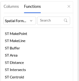
Standardise spatial function naming with ST_ prefix
Rename `make_point()` and `make_line()` to ST_MakePoint() and ST_MakeLine. The 'ST' makes it clear we are working with spatial types, and matches the convention used in the wider geospatial ecosystem
Not looking to turn ZA into a fully-fledged GIS tool, but I would like to see more progress on the spatial side of Zoho Analytics. Being able to visualise data as maps is hugely impactful for analysts and business leaders alike, so upgrades in this department will not go unappreciated!
Does anyone else feel limited by the spatial capabilities in Zoho Analytics? Would anyone else like to see expansion here?